
Photographing Lion Mountain
Lion Mountain photographs well because it looks like something, which most mountains do not. The profile only works from certain angles, the light flatters it at certain hours and the airport next door rules out casual drone flights. This page sets out where to stand, when to be there and what to respect on the way.
Read the guide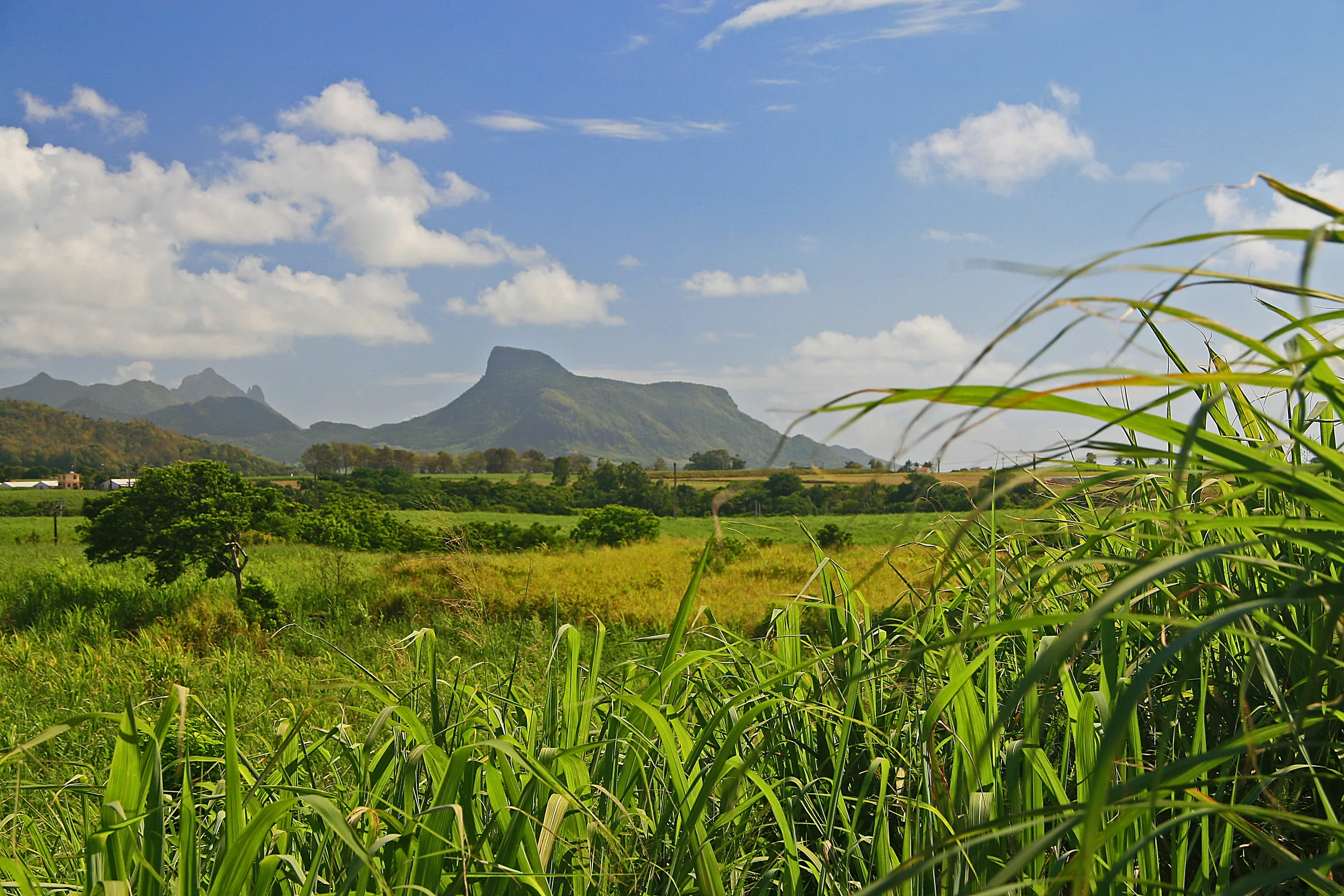
Where the lion reads best
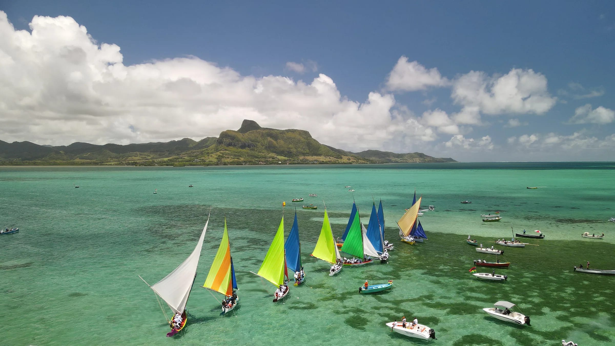
The lion is a profile, and a profile needs distance and the right angle. The long back rises gently from the south and the rocky head lifts at the northern end, so you want to stand roughly side-on to the ridge with the whole length in frame. The classic place is the Mahébourg waterfront, about 5.8 km from the summit across the water. Walk out to Pointe des Régates, where the 1899 Battle of Grand Port memorial stands, and the lion lies along the far shore with the bay in front of it. This is the view the town has lived with for two centuries and the one most people recognise.
Closer in, the coast road north of Vieux Grand Port passes through Bois des Amourettes, a village that sits between the mountain and the bay. From here the head towers over the road and the profile compresses, which gives a more dramatic, less literal picture. From a boat in the lagoon the mountain sits behind the reef and the islets, and the water does half the work. Inland, the cane fields behind Vieux Grand Port give the shot that an old Commons photograph calls the Mauritian Sphinx, with green cane in the foreground and the head above it.
Light through the day
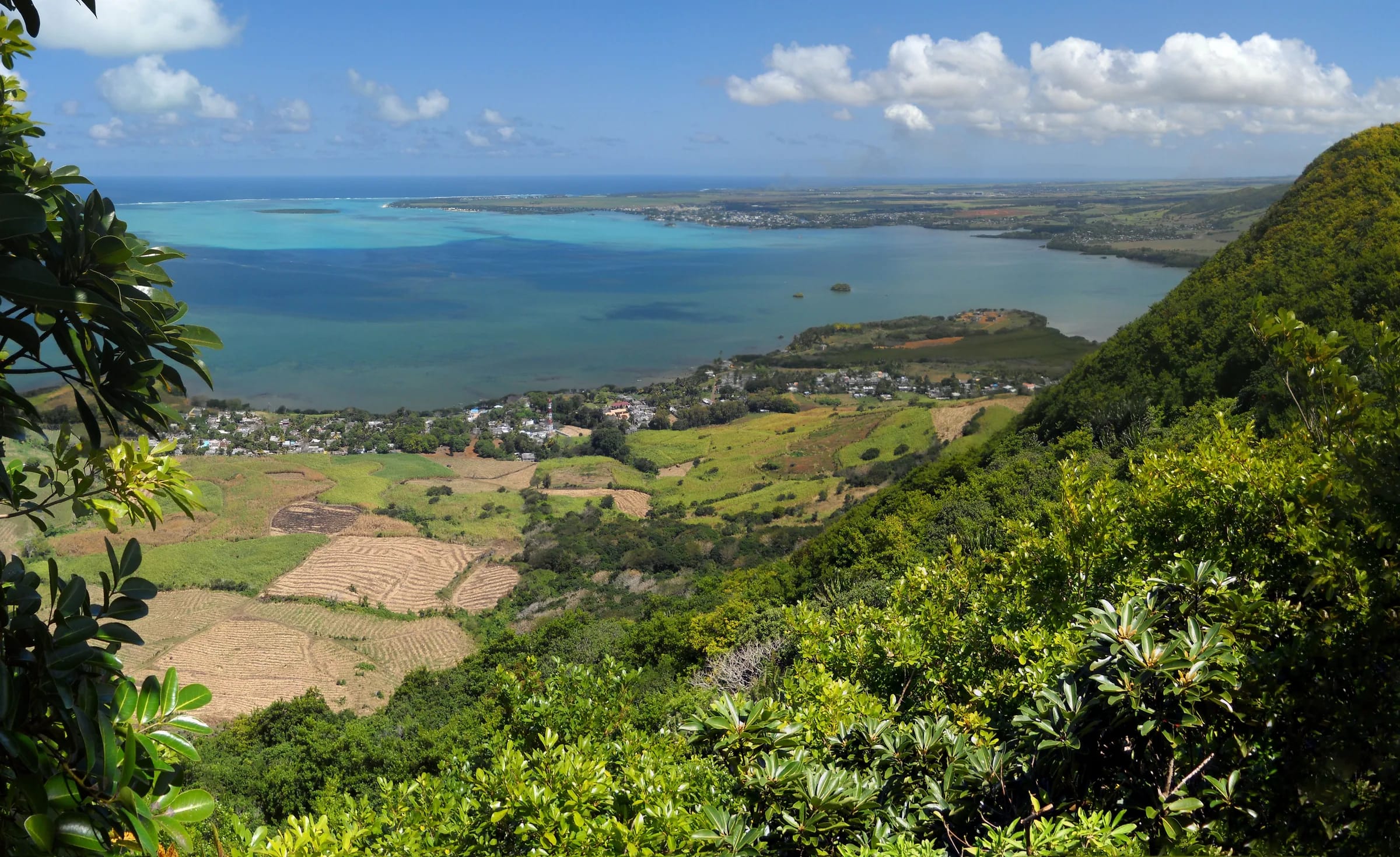
The geography is simple. The bay of Grand Port opens to the east and south-east, the mountain stands on its north-west shore and Mahébourg looks at it from the south-south-west. The sun comes up over the sea, so in the first hours the seaward face of the lion is lit and the views from the coast road and the lagoon are front-lit and clean. From the ridge at that hour you look down into the light, and the bay turns to glitter with Île aux Aigrettes and the reef as dark shapes on it. It is a strong picture but a hard one to expose, so bracket.
By late afternoon the sun has crossed to the west and sits over the Bambous range. The flank that faces Mahébourg takes warm side light, which is when the waterfront view is at its best, and the ridge line sharpens against the sky. From the east, on the coast road or out on the water, the mountain has become a silhouette with the sunset behind it. Dusk is short this close to the equator, around 20 minutes, so be in position before the sun touches the hills.
Midday is the worst time for the profile and the best for the lagoon. With the sun overhead the water shows every shade of blue from the summit and the flag viewpoint, while the mountain itself flattens into a grey mass from below.
Haze, cloud and when the air is clear
The south-east trade winds bring moisture straight onto this coast, which is why the east receives far more rain than the west and why the ridges often wear a cap of cloud. Hikers report fog and rain high on the mountain even in winter, and warm summer air carries haze that softens everything beyond a few kilometres. For long views to the airport, the reef and the Bambous range you want the drier months from May to November, a morning start and ideally the clearer air that follows a front.
Cloud is not always the enemy. A ceiling sitting on the Bambous range behind the lion gives the profile a dark backdrop, and a shower moving across the bay with sun behind it is one of the better pictures the south-east offers. Check the forecast for the south-east specifically rather than for the island, because the two can differ a great deal.
The eastern viewpoint with the flag
The best-known photograph from the mountain is not taken on the summit. The eastern ridge, which forms the second half of the loop mapped on this site, carries a viewpoint where a Mauritian flag has been fixed above the rocks. From it the bay, Mahébourg and the line of the barrier reef lie open below, and hikers who have done both say the view here beats the top, where trees block part of the panorama. A Komoot highlight nearby, named for its view of Mahébourg and the sea, carries a full five-star rating from 23 users.
The viewpoint is on exposed rock above steep ground. Compose with your feet planted, do not step backwards for a wider frame and keep the tripod low in wind. The eastern descent beyond it is rockier than the main spine, which is why hikers advise walking the loop so that you go up the eastern ridge and come down the main path, or simply return the way you came.
Framing from the summit
The lion’s head is small, exposed and sometimes busy, so decide what you want before you arrive. A wide lens takes in the arc of the bay with the lagoon and reef, and the cane and inland ridges on the other side. A longer lens picks out Île aux Aigrettes, about 6.6 km away in the lagoon, the waterfront of Mahébourg at 5.8 km and the runway of the airport at 8.8 km, where aircraft on approach pass within sight of the summit.
Trees crowd part of the summit, so the clean panorama is from the rock itself, and that is where the drop is. Put the camera strap over your shoulder rather than round your neck where a gust can catch it, and treat the flag viewpoint as the better all-round frame. Early morning gives the clearest air; by mid-morning in summer the airport can already be soft in haze.
Drones, and why not here
The summit is about 8.8 km from the airport reference point and the trailhead about 7.4 km, well inside the smallest arc of the airport control zone, which Mauritian aviation charts draw at 8, 11 and 13 nautical miles. The Department of Civil Aviation’s guidance for leisure drones under 7 kg is blunt. Flights are permitted only by day, only over private property with the owner’s permission, no higher than 400 ft, and not over any area where the public can gain access or in the vicinity of the airport. A public mountain beside an international runway fails on at least two counts.
New Civil Aviation (Unmanned Aircraft System) Regulations replaced the old rules from 1 January 2025, and a published summary of them lists fines of up to Rs 1,000,000 and up to 12 months in prison. If you want aerial pictures of the lion, the only legitimate path is written authorisation from the Department of Civil Aviation. The drone page on this site goes through the regulations in detail.
People in the village and on the water
Vieux Grand Port is a working village, not a viewpoint. The trail starts behind the police station and runs between houses before it enters the cane, so you are walking through people’s daily lives with a camera out. Ask before you photograph anyone, especially children, and accept a no. The same goes for fishermen at the jetties along the coast road and for the Monday market in Mahébourg, where stall holders are there to sell rather than to pose.
Mahébourg’s waterfront is more relaxed, and the memorial at Pointe des Régates is a public monument you can frame freely. Along the river under the Cavendish Bridge people still do their washing at La Board, and that is a scene to walk past rather than to shoot. Carry the camera with the same care you would anywhere, keep valuables out of sight in a parked car and be back at the car before dark.
Viewpoints at a glance
The table gathers the places on this page with what each gives you and when it works. Times assume a clear day; cloud on the Bambous range changes everything.
| Viewpoint | What you see | Best time |
|---|---|---|
| Mahébourg waterfront and Pointe des Régates | The full lion profile across the bay, with the 1899 memorial in the foreground | Late afternoon for warm light on the flank, early morning for clean air |
| Coast road at Bois des Amourettes | The head close up above the road and the water | Morning, with the sun on the sea face |
| From a boat in the lagoon | The profile behind the reef and the islets | Morning, when the sea face is lit |
| Cane fields behind Vieux Grand Port | The sphinx view, cane in front and the head above | Early or late, when the light is low |
| Eastern viewpoint with the flag | Mahébourg, the lagoon and the line of the reef | Early morning, before haze builds |
| The lion’s head | The whole bay, Île aux Aigrettes, the airport runway and the inland ridges | Early morning for clear air, midday for lagoon colour |
| Ridge junction towards the west cliff | Cane and the Ferney valley inland | Mid-morning, once the valley is out of the mountain’s shadow |
Questions people ask
Where is the best place to photograph Lion Mountain?
For the lion shape, the Mahébourg waterfront at Pointe des Régates, about 5.8 km across the bay, where the whole ridge lies side-on with the water in front. For drama, the coast road at Bois des Amourettes puts the head directly above you. For the view from the mountain, the eastern viewpoint with the flag beats the summit, where trees block part of the panorama.
What time of day is best?
Morning for the mountain’s sea face and for clear air, late afternoon for warm light on the flank that faces Mahébourg, and sunset for a silhouette from the east side of the bay. From the ridge, early morning gives glitter on the water and midday gives the strongest lagoon colour. Dusk lasts about 20 minutes, so arrive early.
Can I fly a drone over Lion Mountain?
Not without written authorisation from the Department of Civil Aviation. The summit is about 8.8 km from the airport, inside the smallest arc of its control zone, and leisure drones are not permitted near the airport or over any area the public can access. The 2024 Regulations carry fines of up to Rs 1,000,000 and up to 12 months in prison.
Is the view from the summit blocked?
Partly. Hikers report that trees crowd the top and that the cleanest panorama is from the exposed rock of the head or from the flag viewpoint on the eastern ridge. You still see the whole bay, Île aux Aigrettes and the airport from the summit, but the eastern viewpoint is the better place for a wide, unobstructed frame.
Which lens should I bring?
A wide lens for the arc of the bay and the cane behind it, and something longer for Île aux Aigrettes at 6.6 km, Mahébourg at 5.8 km and the runway at 8.8 km. From the waterfront, a normal lens frames the whole profile. Keep weight down, because the climb is steep and you need your hands on the rock steps.
Is the flag viewpoint safe for a tripod?
It is exposed rock above steep ground, so it is safe only if you treat it that way. Set the tripod low, stay away from the edge, never step backwards to widen a frame and avoid it altogether in strong wind or rain, when the rock is slippery. If drops make you uneasy, photograph from the ridge path below the viewpoint instead.
Know the rules before you fly
The drone page explains the control zone, the 2024 Regulations and how authorisation works.