
Do you need a guide for Lion Mountain?
No permit, guide or fee is required to climb Lion Mountain from Vieux Grand Port, and plenty of people do it on their own. The catch is that the trail is unmarked through the cane and only informally marked higher up, the climb is waterless and exposed, and the final steps onto the lion’s head are genuinely airy. This page sets out what a self-guided hiker has to get right, and the situations where paying for a guide is the better call.
Read the guide
What the rules actually say
Lion Mountain is not a managed site. There is no entrance gate, no ticket office, no opening hours and no permit scheme on the Vieux Grand Port side. The path leaves the village behind the police station, crosses working cane fields and climbs the spine to the summit, and nobody will ask who you are or whether you have a guide. Local hiking guides describe a guide as unnecessary for an experienced hiker in dry weather and advisable if you do not know the terrain.
That makes it unusual among the island’s famous climbs. Le Morne Brabant has a managed upper section run by a heritage trust, and Pieter Both needs ropes and a guide for the summit boulder. The only place near Lion Mountain where you will meet a fee is the Vallée de Ferney, the private conservation estate on the mountain’s northern side, which charges visitors to use its own trails and keeps set hours. If you start from the village, none of that applies.
Finding the start through the cane
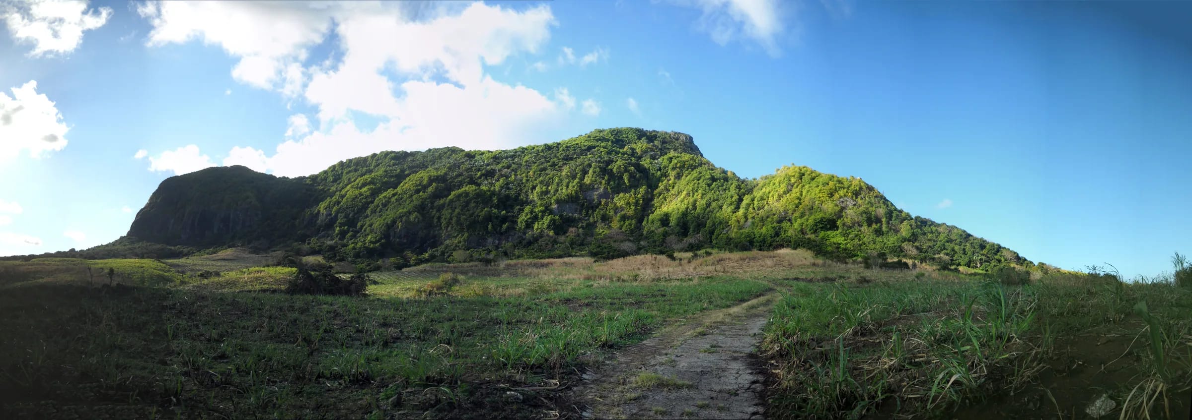
The hardest navigation of the whole day happens in the first twenty minutes. From the police station on the coast road the way into the cane is not signed, and once you are between the rows every track looks like every other track. Guides who have mapped the route describe the trail as poorly marked, especially through the sugar cane, and the OpenStreetMap survey rates its visibility as intermediate at best.
The good news is that the cane section has a simple logic. You are aiming for the middle of the mountain, where the spine comes down to meet the fields, and the main cane road takes you there. Where that road bends away to the right, the footpath carries straight on towards the slope. A large boulder marks the point where the cane ends and the real climbing begins.
Leave the coast road at the police station
Walk inland from the police station in Vieux Grand Port. Within about 100 m a side street, Adrien Street, leads into the cane. Keep the museum grounds behind you and the mountain ahead.
Follow the main cane road
Stay on the widest track and head for the centre of the mountain rather than either end. Ignore side tracks that run parallel to the coast.
Go straight where the road curves right
The vehicle track swings right. The footpath continues straight towards the slope and soon reaches a large boulder.
Climb the root-filled drainage
Above the boulder the path enters the forest and follows a steep gully of roots and rock steps to the crest of the ridge. This is where the GPX file earns its keep.
Reading the trail on the ridge
Once you are on the crest the route is easier to follow because there is nowhere else to go. You will see occasional red paint on rock and yellow ribbon tied to branches. These are informal marks left by hikers and local guides, not an official waymarked system, so they can fade, fall off or point along a variant you did not intend to take. Treat them as confirmation rather than instruction.
At the junction on the ridge a left turn leads to a viewpoint on the western cliff, reached by a steep and slippery descent that is better left for the way down or skipped altogether. The summit is to the right. The eastern ridge path also starts from this junction, dropping down a rocky spine to grassland and back to the cane road, which is how most people close the loop. The last section before the lion’s head is the most exposed part of the mountain, with rock steps that need your hands and a drop on the seaward side. Anyone uneasy with heights can stop just before it and still have most of the view.
Timing, weather and the turnaround
Most hikers need three to four hours for the return trip from the village, including time on top. Fast and experienced walkers do it in around two and a half. Start early, because the upper half of the climb has no shade and there is no water anywhere on the route. In summer the airport weather station at Plaisance records average daytime highs of about 30 °C, and the dark rock holds the heat.
Check the forecast for the south-east specifically, not for Mauritius in general. The trade winds push cloud and showers onto this coast while the west stays dry, hikers report fog and rain high on the ridge, and the thin clay soil stays slippery long after the shower has passed. Thunderstorms are most likely from December to April, and the cyclone season runs from about November to April, with the official warning window to mid May.
Give yourself a turnaround rule before you start. The lion’s head is the natural one. If the rock is wet, if the wind is strong enough to unbalance you, or if anyone in the group is not comfortable, the viewpoint just before the head is a fine place to stop. Dusk is short this close to the equator, around twenty minutes, so plan to be back in the cane well before sunset, which falls as early as about 17:40 in June and July.
- Carry at least 1.5 litres of water per person and drink before you feel thirsty.
- Download the GPX file to your phone before you leave the coast, and carry a paper note of the key junctions in case the battery dies.
- Fix a latest turnaround time as well as a turnaround place.
When a guide genuinely helps
A guide does not make the rock less steep, but there are days and people for whom one is worth every rupee. If this is your first mountain in Mauritius, a guide saves you the cane-field search and lets you concentrate on the climb. If the forecast is doubtful, a guide knows how the ridge behaves in cloud and will call the turnaround before you have to argue about it. If you are nervous about exposure, a steady voice on the rock steps makes a real difference, and someone who has watched hundreds of people on that section can judge whether you should go onto the head at all.
Guides also carry the stories. The bay below is where the Dutch landed in 1598 and where the Battle of Grand Port was fought in 1810, and a good local guide will point out the fort site, Île aux Aigrettes and the airport runway as you climb. Solo travellers often book a guide simply to avoid going up alone, which is reason enough. Guided outings typically meet in Vieux Grand Port at 07:00 or 08:30 and take about three hours for the climb itself, and the guided page on this site explains how they are organised.
If what you want is a quieter walk with no exposure, the Vallée de Ferney next door offers marked trails from 5 km upwards on the mountain’s northern side, for a fee and within set hours. It is a different experience, in forest rather than on an open ridge, and for some visitors it is the better one.
Never go alone, and tell someone your plan
Every source that gives safety advice on this mountain says the same thing. Do not go alone. One travel writer who climbed it unguided with friends saw nobody else on the whole route, and that is normal here outside weekend mornings. If you turned an ankle in the root gully or slipped on the head, you could wait a long time for the next person to come past. Go with at least one other person, and leave your plan and expected return time with someone at your accommodation.
Phone coverage on the ridge is not something you should count on, and there is no dedicated mountain rescue line in Mauritius. The police answer on 999 and 112, and the SAMU ambulance service on 114. Any call-out will come from the coast road, so knowing where you are on the route, and being able to say so, matters more than on a managed trail with numbered posts. The safety page covers this in more detail.
- Go with a partner and keep the slower person in front on the rock.
- Save 999 and 114 in your phone before you start, and carry the phone where you can reach it with one hand.
- If the group splits, agree a meeting point that is not the summit.
A self-guided checklist for the morning
Most problems on Lion Mountain start in the village before anyone has taken a step uphill. Run through this list before you leave the car, and the mountain itself will look after the rest.
- The south-east forecast is dry, and no cyclone warning is in force.
- The GPX file is on your phone, the phone is charged, and you know where the main cane road bends right.
- Everyone has at least 1.5 litres of water, sun protection, repellent and shoes with grip.
- You have agreed a turnaround place and a turnaround time.
- Someone off the mountain knows your plan and when to expect you back.
- Valuables are out of sight in the car, or better, not in the car at all.
Questions people ask
Do you need a permit to climb Lion Mountain?
No. There is no permit, no entrance fee and no booking system on the Vieux Grand Port side. The path crosses cane fields on an informal basis and then climbs the open mountain. The only fee nearby is at the Vallée de Ferney, which charges visitors to use its own trails on the northern side of the mountain and keeps set opening hours.
Is Lion Mountain safe to hike without a guide?
For experienced hikers in dry weather, yes, and many people do it. The route is unmarked through the cane and only informally marked higher up, so a downloaded GPX file is important. The last section onto the lion’s head is exposed and needs hands. Every source advises against going alone, and a guide is sensible if you do not know the terrain or the weather is uncertain.
Is the Lion Mountain trail marked?
Not officially. There are no signposts, numbered posts or maintained waymarks. Hikers and local guides have left informal red paint on rocks and yellow ribbons on branches along the ridge, but these fade and move. Through the cane fields there are no marks at all, and that is where people most often lose the line. Use the GPX file on this site and follow the main cane road towards the centre of the mountain.
Where can I download the Lion Mountain GPX?
The mapped spine from Vieux Grand Port to the summit and the eastern ridge loop are both available as GPX files on the trail map page of this site. Load the file into an offline mapping app before you leave your accommodation, because you should not rely on mobile data on the ridge. The map page also shows the elevation profile so you can see where the steep sections fall.
How long does Lion Mountain take without a guide?
Plan on three to four hours for the return trip, including time on the summit, which is the same whether or not you have a guide. Fast, experienced walkers manage it in about two and a half hours. Add time if you are new to the route, because finding the way through the cane on your first visit can easily cost twenty minutes.
Can I hike Lion Mountain alone?
You can, because nobody will stop you, but no source recommends it and neither does this guide. The route is quiet, the rock steps are exposed, and a simple slip could leave you waiting a long time for help. Go with at least one companion, or book a guide if you are travelling solo. If you do go alone anyway, leave a detailed plan with someone and fix a strict turnaround time.
Get the map before you go
The trail map page has the mapped route, the elevation profile and GPX files for the spine and the eastern loop.